Charting the Enigma of Zealandia: 8th Continent
In the realm of scientific exploration, researchers have unveiled the most precise map to date of Zealandia, a submerged landmass often referred to as the “8th continent.” However, the notion of continents becomes somewhat perplexing when viewed through a global lens. Different cultures and disciplines harbor distinct interpretations of what truly defines a continent. For instance, while Indians recognize seven continents, Russians advocate for a merger of Europe and Asia into a single entity. Even the Olympics provide a unique perspective on continents, symbolized by five colored rings that conspicuously exclude Antarctica.
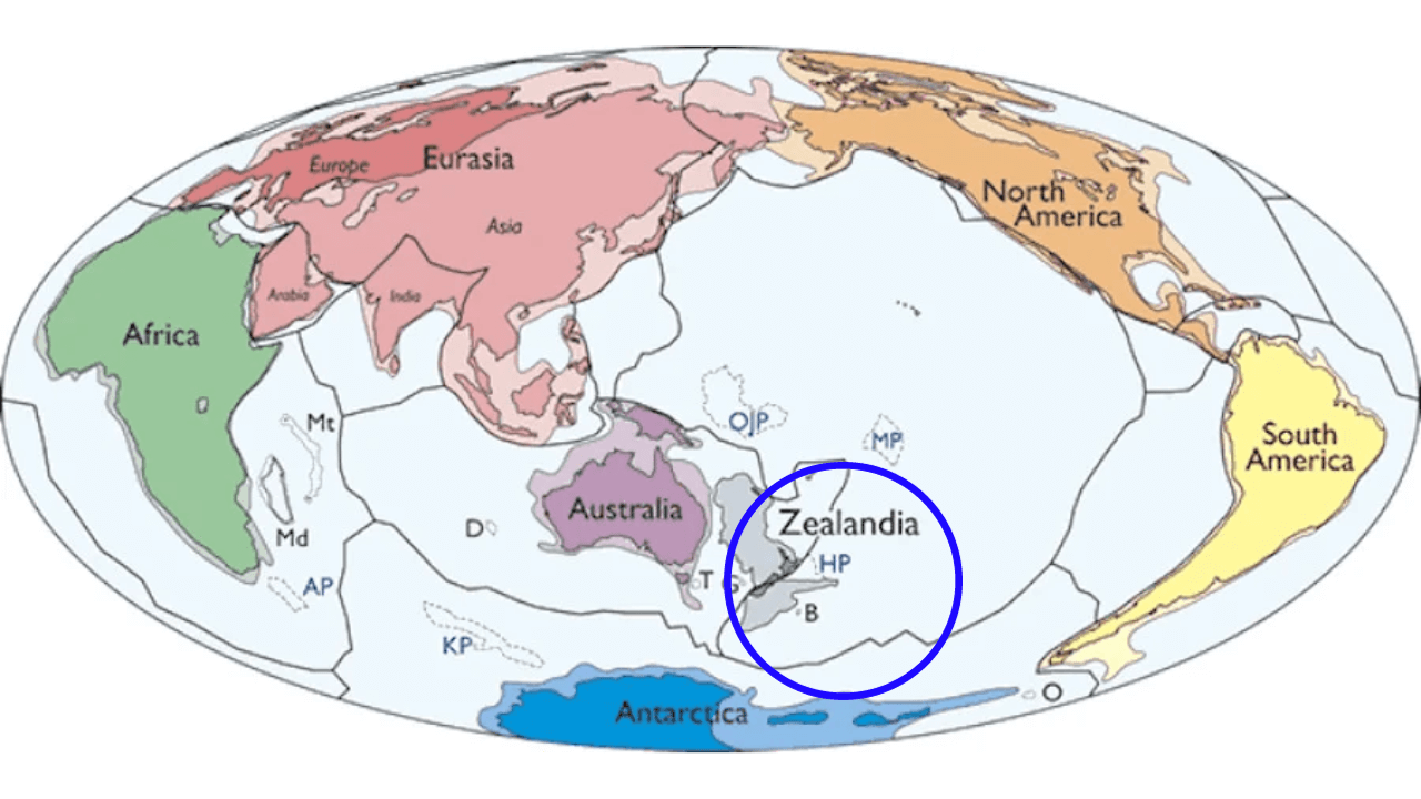
Continents: A Geological Vantage Point
Nevertheless, from a geological perspective, continents align with massive land masses of continental crust resting atop tectonic plates. Earth also holds smaller crustal fragments known as “microcontinents.” Let’s embark on a journey back in time, roughly 23 million years ago, when one such microcontinent, Zealandia, submerged beneath the depths of the Pacific Ocean, leaving a mere 6% above water – the modern-day New Zealand and its neighboring islands. Astonishingly, Zealandia, despite its vast size, remains devoid of the esteemed title of a full-fledged continent.
Zealandia extends over approximately 4.9 million square kilometers, making it half the size of Australia, twice the expanse of Greenland, and even eclipsing the Indian subcontinent in sheer size. While many geologists contend that Zealandia impeccably meets all the criteria for full continent status, it curiously lacks even the modest “sub” prefix.
Unraveling Zealandia’s Mysteries
Beyond the intricacies of nomenclature, experts have diligently toiled to delineate Zealandia’s boundaries and decipher its geological intricacies. This formidable endeavor proves exceptionally challenging due to Zealandia’s extensive submersion beneath the ocean’s depths. Recent advancements, including the retrieval of rock samples from the ocean floor in the region, have been pivotal in these efforts, culminating in the most precise map of Zealandia to date. These cartographic undertakings entail the meticulous analysis of rock and sediment samples procured from drilling sites, along with the scrutiny of seismic and magnetic data. These investigations unveil vital geological features such as subduction zones and slips, which are paramount for establishing more defined tectonic boundaries.
Considering the compendium of available evidence, scientists conjecture that the region’s intriguing magnetic anomalies, particularly the enigmatic Campbell Magnetic Anomaly, likely originated during the Gondwana breakup – an ancient supercontinent encompassing various landmasses, including India and Zealandia. This pivotal event eventually paved the way for the formation of Zealandia’s oceanic floor, a captivating chapter in Earth’s ever-evolving geological saga.
- RRB JE Science Syllabus 2026, Check General Science Topics
- RBI Grade B Phase 2 Exam Analysis 25th and 26th July 2026
- JAIIB Success Story: Shweta Kumari’s First-Attempt Strategy Every Banker Should Know
- Attempt PNB LBO Practice Quiz and Download Free PDF
- 10 Years of Persistence: How Nishant Kumar Vatsa Cleared Bank of India Credit Officer Scale III Exam

Priti Palit, is an accomplished edtech writer with 4+ years of experience in Regulatory Exams and other multiple government exams. With a passion for education and a keen eye for detail, she has contributed significantly to the field of online learning. Priti’s expertise and dedication continue to empower aspiring individuals in their pursuit of success in government examinations.