
Landforms on Earth: The planet Earth is one of the most unique planets for one reason- it is the only planet that supports life as of now. Earth is diverse in form and features. This blog will focus on the features of the land. That is the different landforms on earth, their types, and their unique characteristics. These are also vital for various exams. So let’s get into it!
Landforms on Earth: Types and Characteristics of Landforms
There is a rich diversity when it comes to landforms on earth. The following are some of the major landforms one can find on earth:
- Mountains
- Hills
- Plateaus
- Plains
Aside from these major landforms, the following minor landforms also exist:
- Buttes
- Canyons
- Valleys
- Basins
Let’s study these landforms in detail:
Major Landforms on Earth
1. Mountains
Mountains cover approximately 1/5th of the Earth’s surface. Around 80% of the world’s freshwater comes from the mountains. The characteristics of Mountains vary depending on their location, altitude, biomes and the body of water that surrounds them, and their distance from the equator.
There are a few features that are common among all mountains:
- Higher elevation than the surrounding areas
- Mountains have steep slopes, sharp/round ridges, and a peak/summit
- They’re formed by volcanic or tectonic activities
- High relief within the mountain ranges
Mountains experience higher precipitation than other ecosystems. The weather in mountains varies according to location and altitude. The weather in mountains is also highly unpredictable and can change drastically within minutes in some places. One minute it’s a clear sky and the next minute it’s a thunderstorm. Temperatures can fall below zero degrees within minutes. Mountains are always threatened by a wide range of natural disasters, erosion, and lava flows.
Despite its unpredictable weather, mountains have great biodiversity and are home to thousands of species of animals and plants. Due to the sensitive living conditions in mountains, there is a large number of plants and animals that are endangered. Around 10% of the world’s human population lives in the mountains.
Types of Mountains
Mountains are of different types depending on their features. Here’s how most mountains are classified:
Volcanic Mountains
Volcanic mountains are formed when molten rocks from inside the Earth’s crust erupt and pile up. Examples of volcanic mountains are Mount Fuji in Japan and Mount St. Helens in Washington State.
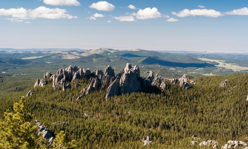
Dome Mountains
Magma pushing through the Earth’s crust, and hardening inside the crust before erupting out of the surface forms dome mountains. Rains and wind strike the domes, and sculpt valleys and summits. Popular examples are the Black Hills of South Dakota and the Adirondack mountains of New York.
Plateau Mountains
The formation of plateau mountains is similar to that of Dome mountains, except that, plateau mountains are formed due to tectonic activities when tectonic plates push up the crust without faulting/folding. Plateau mountains are then shaped by erosion and weathering processes.
Fault-block Mountains
These also occur due to tectonic activities. Fault-block mountains are formed when there is stress between tectonic plates. This leads to the cracking of the surface of the Earth, forcing the rocks up and down. Examples of fault-block mountains are the Sierra Nevada and the Harz.
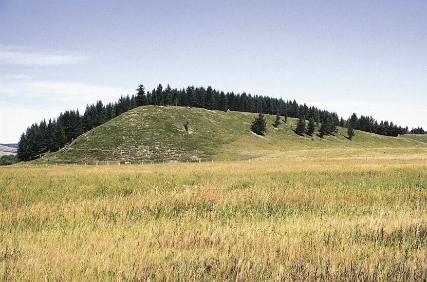
2. Hills
Hills have been homes to hundreds of people in rural as well as urban areas for hundreds and thousands of years. A lot of people build their homes on hills to avoid floods and defend themselves, for instance, in Ancient Rome.
Types of Hills
Drumlins
Drumlins are elongated hills (they look like an inverted spoon) formed by the movement of glacial ice on the underlying till. These occur in different sizes and shapes (parabolic, symmetric, etc.) and are typically 1 – 2 km in length. They’re less than 50 meters high and are 300-600 meters wide and are mostly composed of glacial till, gravel, and sand in varying proportions.
Drumlins form near glaciers/ice sheets and have the most of the glacially-formed features (scours, eskers, valleys).
Tor
Tors (castle koppies/kopjes) refer to the rock formation on top of hills or sometimes referred to the hill itself. These are free-standing rocks, that rise in smooth surroundings. Tors are created by erosion/weathering of rocks like granites, dacites, dolerites, coarse sandstones, etc., and are mostly 5 meters high.
Puys
Puys are volcanic hills that are cone-shaped. They are also called cinder cones and may or may not be associated with lava. They’re found in clusters or lines or sometimes isolated and scattered.
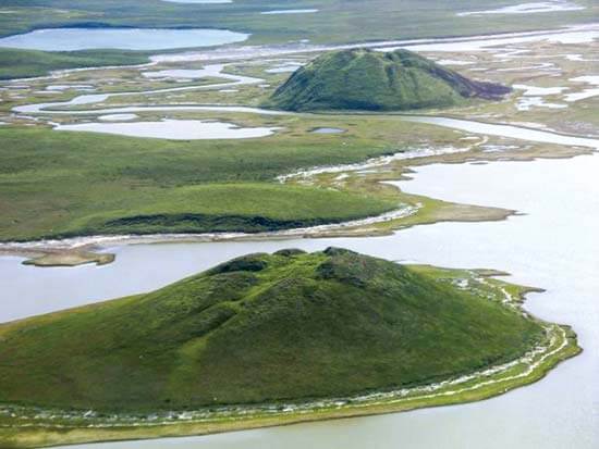
Pingos
Pingos are periglacial (or non-glacial) mounds of earth-covered ice, that are mostly found in Antarctica and Arctic & Subarctic regions. They can reach up to a diameter of 600 meters and heights of up to 70 meters.
3. Plateaus
These are high flat surfaces that stretch for thousands of kilometers. Plateaus that are eroded by the flow of rivers are among the most uniform in terms of elevation, though their surfaces can be interrupted by canyons. Plateaus are formed by crustal shortening/volcanic activities/thermal expansion (of the lithosphere) and are found on most of the continents.
Erosion influences the shapes of plateaus in drastic ways. When erosion is heavy, the plateaus are broken up into smaller raised landforms called outliers, which are composed of old and dense rock formations. Outliers contain iron ore and coal.
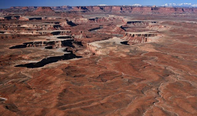
Dissected and Volcanic plateaus.
Dissected plateaus are formed when tectonic plates collide slowly, resulting in an upward movement on the earth’s crust. A popular example is the Colorado Plateau (Western US) which has been rising 0.3 centimeters a year for 10 million years.
Volcanic Plateaus
These are formed by lava that flows out of small volcanoes that slowly build up over time from plateaus. For instance, the North Island Volcanic Plateau (The central part of North Island in New Zealand).
Other types of this landform include:
Intermontane Plateaus
Intermontane plateaus are the highest plateaus in the world and are surrounded by mountains. The Tibetan plateau is the highest intermontane plateau.
Piedmont Plateaus
Piedmont plateaus are plateaus that have mountains on one side and a sea/plain on the other. Popular examples are Malwa Plateau, Patagonian plateau, etc.
Continental Plateaus
These are vast plateaus that are surrounded on all sides by oceans/plains. Continental plateaus form away from the mountains. Examples: Antarctic plateaus, Polar plateau, etc.
4. Plains

Grasslands
These are vast stretches of plain regions, with grass as the primary type of vegetation. The great plains, that are found across most of Central North America, are grasslands.
Prairies
Temperate grasslands that are popularly found in North America. Prairies can grow up to 1.5 meters high depending on the weather. Tall prairies are plowed under and aren’t usually farmland or pasture.
Steppes
Steppes are temperate grasslands of Eastern Europe and Asia. These areas do not receive enough rainfall to grow tall grass or trees.
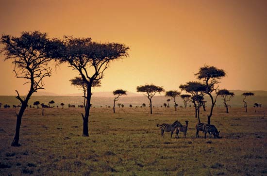
Savannas
These are tropical grasslands, which exist in places with warm temperatures throughout the year. Savannas often have trees that scatter and stretch across much of Central Africa and are also present in Australia and South America and some parts of North America.
Not all the plains are grasslands. There are some plains that are forested (like the tabasco plain of Mexico). These have diverse types of vegetation, like trees and shrubs. Parts of the Sahara desert are plains. The Arctic areas also have plains and they’re called Tundra. Tundra is plains where the ground is frozen. Tundras, despite being cold, are home to a lot of plants, including moss and shrubs.
Flood Plains
Flood plains, as the name suggests, are formed when sand, sediment, and mud carried by floods pile up on land. Due to this reason, flood plains are extremely rich in nutrients and create fertile land for farming. One of the most popular examples of flood plains is the flood plain surrounding the Nile River of Africa, which has helped Egyptian civilization to thrive for centuries.
Alluvial Plain
These plains form at the base of mountains; they’re formed when water-carrying rocks and sediments flow downhill till it hits the flatland. The sediment is deposited on that plain (in the shape of a fan). One of the popular examples is the Huang He River in China, which has created an alluvial plain that stretches for kilometers. The Huang He River is also called as the Yellow River because of the yellow-colored sediment it carries.
Coastal Plain
When rivers carry sediment and dump the sediment in the ocean, it builds up and eventually rises above the sea level, forming a coastal plain. These plains slope gently under water.
Abyssal Plain
Abyssal plains are plains found at the bottom of all the oceans. These are approximately 5000-7000 meters below sea level. Abyssal plains are considered the flattest and smoothest surfaces on earth.
Minor Landforms on Earth
1. Buttes
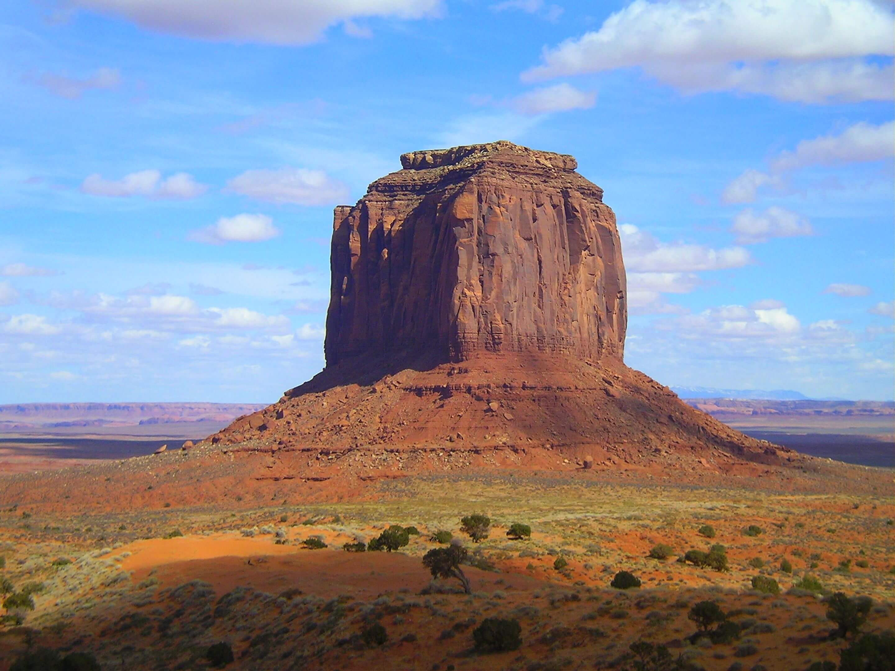
Butte is a type of hill that usually stands isolated in a flat area. Buttes, like mountains, have steep sides and flat tops. Buttes are smaller than landforms such as plateaus, mesas and table. While mesas have wider tops, buttes have narrower tops.
One of the popular examples of Buttes is, the Mitten buttes in Arizona.
Buttes are formed by erosion and weathering.
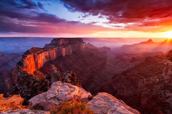
2. Canyons
Canyons are deep and narrow valleys in the crust of Earth’s surface. These are formed by flowing rivers that make deep cuts in the terrains. Canyons are also found on the ocean floors. One of the most popular canyons on Earth, is the Grand Canyon, which is cut by the Colorado River and is 277 miles long.
Types of Canyons
Box Canyons
Box canyons are formed when parts of a wall collapse back onto the land. The heads of these canyons are often marked by cliffs on three sides of it.
Slot Canyons
These are narrow pathways, sliced into eroding plateaus, by rushing river water. Slot canyons are very deep, though they are just few feet wide.
Submarine Canyons
Submarine canyons are canyons formed underwater. These are similar to the ones on land but are cut by ocean currents. Most submarine canyons are extensions of river canyons, that flow across the continental shelf.
Gorges
Small and steep-walled, V-shaped valleys, cut through by rivers that occur in upper courses of rivers, where the currents are strong and swift.
3. Valleys
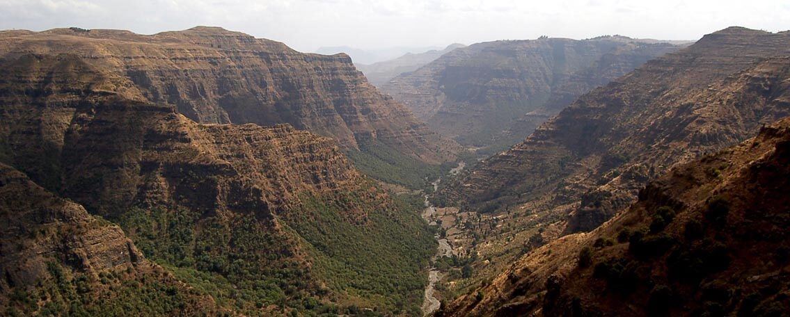
Valleys are formed by flowing rivers and the movement of glaciers. These are elongated depressed areas on land which are washed out by the forces of ice and water. Valleys are usually U or V-shaped. Most valleys are cut through by streams/rivers. Valleys can occur on flat land or between hills and mountains. Valleys are usually drained rivers.
Types of Valleys
Side Valleys
Formed by tributaries of rivers.
Hollow Valleys
Small-sized valleys that are nestled between hills or mountains.
Rifts
These are giant valleys, formed when the crust of Earth is separated/split. Example: Great Rift Valley. Rift valleys are formed by tectonic activities.
4. Basins
Basins are shallow dips/depressions on the surface of the Earth. They occur in the shape of bowls. Basins have different shapes, like circular basins, oval-shaped basins, etc. While some basins are filled with water, others are dry. Basins are formed by erosions/earthquakes; while some take years to form, some are formed overnight.
Types of Basins
River Drainage Basin
River drainage basins are basins that are drained by rivers and all their tributaries. They’re made up of watersheds. Every tributary or stream of rivers has its own watershed and these are part of the river basin. For example, the Mississippi river basin is made up of six major watersheds, namely, Missouri, Upper Mississippi, Lower Mississippi, Askansas-Red-White rivers, Ohio and Tennessee.
The Amazon river basin is the world’s largest.
Structural Basins
Tectonic activity or weathering and erosion often form structural basins and they are often present in dry areas. Structural basins look like a cluster of bowls stacked inside each other. Structural basins have internal drainage systems and don’t have sufficient water to drain into water bodies. Water that enters these basins generally seeps inside the ground or evaporates and when a lot of water accumulates, it can become a salty lake, like the Dead sea.
Lake Basins
A lake basin is a type of structural basin that forms when rocks/debris left by landslides/lava flow block valleys. These blockages act as dams and trap water to form a lake. For eg. the Hunza lake in Pakistan. The movement of glaciers may also form lake basins.
Sedimentary Basins
A sedimentary basin is also a type of structural basin, which sometimes forms long troughs. They are full of layers of organic material and rock (Sediment fill), which later become key sources of petroleum and other fuels.
Ocean Basins
Ocean basins are some of the largest depressions on the surface of the earth. The Continental shelves form the sides of these basins. The five major ocean basins on Earth are the Atlantic basin, the Pacific basin, the Indian basin, the Arctic basin, and the Southern basin. Tectonic activities/spreading of seafloor/subduction form most ocean basins. They also make up almost 70% of the land on Earth.
Landforms on Earth: Conclusion
There are diverse landforms on earth and many are yet undiscovered. However, these would be the major and well-known landforms that you can learn about. You can find more geography-based notes here.
And for more banking and government exam-related content make sure to check out our YouTube channel!
Frequently Asked Questions
Some major landforms on the earth’s surface are mountains, hills, plateaus and plains.
Some minor landforms on the earth’s surface are buttes, canyons, valleys and basins.
Valleys are formed flowing rivers and moving glaciers. The movement of water or ice erodes the land over years causing deep cuts to form.
Flood Plain: formed by the accumulation of sand, mud, and silt due of floods. These plains are abundant in nutrient rich soil. This makes them ideal for agriculture. Flood plains have popularly been the site for major civilizations due to this.
Alluvial Plain: Formed at the base of mountains. Rivers flowing downstream accumulate sediment at the base of mountains that eventually develops into alluvial plains.
- CAIIB BRBL Module Wise Important Topics, Weightage and Study Plan
- Attempt JAIIB IE & IFS Monetary and Fiscal Policy Quiz & Download PDF
- Attempt JAIIB IE & IFS Business Cycle Practice Quiz & Download PDF
- IBPS SO Bank Preference List 2026: Best Bank Order & Tips
- World Development Report 2026, All About AI and Growth

The most comprehensive online preparation portal for MBA, Banking and Government exams. Explore a range of mock tests and study material at www.oliveboard.in